Increase resilience to changes in water availability (variability and climate change)
| 4.1 | New actions to improve and apply our understanding of climate variability and change |
| 4.2 | Review water allocation and water sharing in response to new climate information |
| 4.3 | Improve drought planning, preparation and resilience |
| 4.4 | Better integrate land use planning and water management |
Our aspiration
Water resource management is supported by the most up-to-date understanding of climate, including climate change and associated risks to water resources. This understanding is reflected in strategic planning and supports water management decisions.
Key challenges and opportunities
Australia has a highly variable climate, and rainfall is especially variable. This makes it vital that we understand as much as we can about our climate so we can work out how we manage our water supplies. The frequency and duration of wet and dry events determines how much water we have available.
NSW is already experiencing trends of higher average temperatures and reduced cool season rainfall. There are indications from climate models that drought conditions may become more frequent and severe, and last longer.
Higher demand from a growing population, alongside reductions in supply, will increase water scarcity, putting further pressure on all users, including the environment (Productivity Commission, National Water Reform Issues Paper, May 2020, p.2).
It is vital that we collectively improve our understanding of these risks to better manage water supply and ensure that our operational, planning and future development decisions take future likely water reliability and security into account.
Net Zero Plan - taking action on climate change
The NSW Government is committed to achieving net zero emissions by 2050 and to making NSW more resilient to a changing climate.
The Net Zero Plan Stage 1: 2020-2030 is the foundation for NSW’s action on climate change. The Plan aims to grow the economy, create jobs and enhance the prosperity and quality of life of the people of NSW while allowing the state to deliver a 35% cut in emissions by 2030 compared to 2005 levels.
The NSW and Australian governments are jointly investing more than $2 billion over 10 years to help the state fast-track climate action through energy and emissions reduction initiatives delivered under the Plan. This includes actions targeting energy efficiency, electric vehicles, hydrogen, primary industries, coal innovation, organic waste and carbon financing.
The implementation of the Net Zero Plan, together with the NSW Electricity Strategy, will result in more than $11.6 billion of new investment for NSW, including $7 billion in regional NSW, and support the creation of almost 2400 new jobs.
The Climate Change Fund is supporting programs and projects to improve NSW’s resilience to natural hazards and climate risks. This includes investment in world-leading climate research, support for councils, communities and agencies to better prepare for and respond to heatwaves, storms, floods, droughts and bushfires,
the Five Million Trees initiative and coastal risk management programs.
The Government is also delivering local scale climate change adaptation programs to help communities understand the impacts of climate change in their areas and prepare for and adapt to these impacts, including taking action to protect ecosystems and vital natural assets and resources. Find further information on these and other climate change actions.
Use best available data, methods and modelling to inform decisions across the water sector
Until now, our water management decisions have been made on just 130 years of observed climate records. The NSW Government is investing in new, state-of-the-art climate data and modelling that brings together information from a variety of sources to improve our understanding of past climate conditions and plausible climate futures.
This new modelling, which is being adopted as part of the development of the regional and metropolitan water strategies, will provide a more accurate picture of the frequency, duration and magnitude of extreme climate events such as extended droughts and floods, and indicate plausible, more extreme scenarios that may emerge over the next 40 years due to climate change.
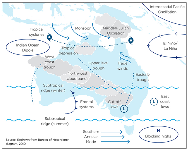
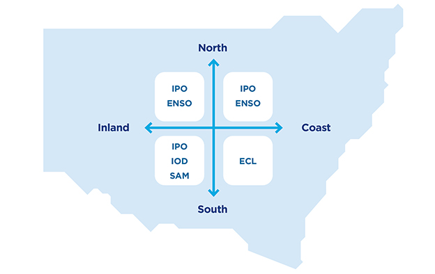
NSW’s climate is affected by almost all the major weather and climate drivers on the Australian continent at some stage through each year.
East coast lows (ECLs) and the major oceanic climate drivers - El Niño-Southern Oscillation (ENSO), the Interdecadal Pacific Oscillation (IPO), the Southern Annular Mode (SAM) and the Indian Ocean Dipole (IOD)—all interact over NSW, producing a highly variable climate from year to year and between seasons.
Figure 18 shows the various climate drivers influencing rainfall in Australia and Figure 19 shows the relative influence of these climate drivers in different parts of NSW. The complex effects of these climate drivers result in the extended periods of wet and dry that NSW experiences.
Source: Office of the Chief Scientist & Engineer, April 2020, Independent review of the climate risk method for the NSW Regional Water Strategies Program
Our 130 years of recorded information provides a good indication of average conditions, and shows a small number of extreme droughts and floods. We are now using paleoclimate records to better understand the likelihood of these extreme events. By analysing sources such as tree rings, cave stalactites and stalagmites, river sediments, soil patterns, and ice cores, we can identify the past duration and frequency of these events, for periods up to 500 years. We have combined this with our recorded information and our understanding of the key climate drivers, using statistical techniques, to generate 10,000 years of plausible past climate sequences. This information provides a better source of information to identify and assess the potential risks and outcomes of water management decisions under our current climate.
We have then combined this new 10,000 years of ‘current’ climate information with the climate change information provided by the NSW and ACT Government’s NARCliM project (see box on next page) to investigate the impacts of future human induced climate change on our rainfall and evaporation across the state. The method was developed by Department of Planning, Industry and Environment - Water with advice from the Universities of Newcastle and Adelaide. This new data and modelling approach has been independently reviewed by the Office of the NSW Chief Scientist and Engineer and a panel of independent experts and found to be best practice and a major advance on existing approaches.
We are considering worst-case scenarios
The NSW and ACT Regional Climate Modelling (NARCliM) Project is a research partnership between the NSW and ACT governments and the Climate Change Research Centre at the University of NSW.
NARCliM climate change datasets include a range of different future climate scenarios. We have used the most conservative result from NARCliM in our modelling for the regional water strategies - the scenario that represents the greatest reduction in average monthly rainfall. While the results of the other scenarios in the current version of NARCliM are arguably equally appropriate and probable, we intend to ‘stress test’ the water system and understand the worst-case climate scenarios for strategic water planning. This will test the resilience of options proposed in the regional and metropolitan water strategies, particularly options that aim to secure water for critical human needs.
| Climate variability data | Observed historical Rainfall and temperature Evaporation data | + | Paleoclimate data* Reconstructed data
| = | 500+ years of |
|---|---|---|---|---|---|
+ | |||||
Climate drivers | |||||
↓ | |||||
Stochastic modelling | = | 10,000 years of | |||
| Climate change projections | Climate change projections | = | Plausible future | ||
This new climate data is now being used in river system models to compare the outcomes of water-related policy, planning and/or infrastructure options. This enables us to test how effective different options—such as a pipe, dam or change in a rule or policy - might be in extreme scenarios, compared to other options.
The overall message from the new modelling is that our water supplies in NSW could be less secure than we thought. This is because we have now factored in that droughts longer than those of the last 130 years are likely at some point and that we could see higher temperatures, higher rates of evaporation and less rainfall - leading potentially to reduced river flows and more frequent low flow periods, decreased inflows into dams and water storages, and lower water storage levels.
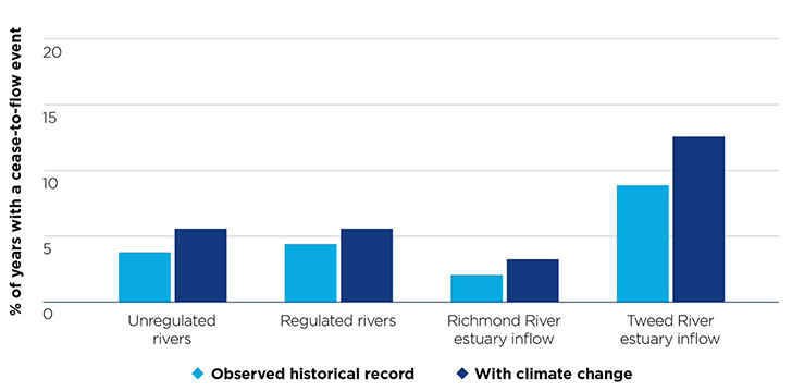
This data has been used to investigate potential climate impacts in a number of locations across NSW and will be presented for each region as part of the regional and metropolitan water strategies. Figures 21 and 22 show examples of how this new modelling is being used to explore potential impacts in the Macquarie and Far North Coast regions.
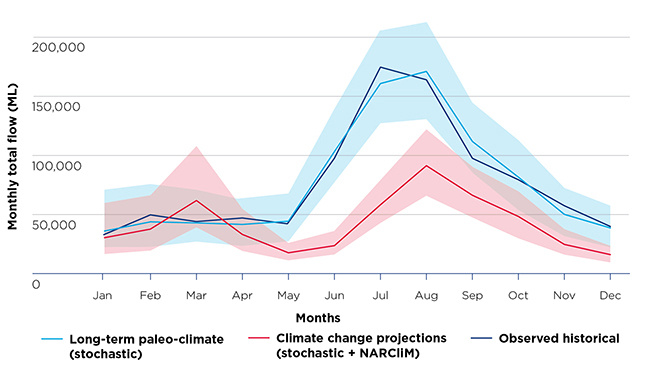
Source: Department of Planning, Industry and Environment—Water 2020, hydrological modelling
Note: The shaded area represents a 95th percentile confidence interval which means a high degree of confidence that values will fall within the shaded range based on the climate projection scenario.
Source: Department of Planning, Industry and Environment - Water 2020, hydrological modelling
Action 4.1 New actions to improve and apply our understanding of climate variability and change
The Government will continue to improve our understanding of climate, including variability and climate change, and ensure that it is applied and accessible to inform decisions across the water sector. We will:
Actions | Horizon 1 | Horizon 2 | Horizon 3 | |
| a. | include new climate data and risk modelling methods in the NSW Common Planning Assumptions | X | ||
| b. | provide access to climate risk information for water users, councils and local water utilities, and the community to support towns and users adapt to likely reduced water reliability | X | ||
| c. | incorporate the new climate data into NSW water models, initially for regional and metropolitan water strategies and modelling of new infrastructure projects | X | ||
| d. | partner with key stakeholders and industry to develop communities of practice for climate risk modelling, and to promote improved risk management and adaptation | X | ||
| e. | advocate for use of a single climate risk methodology across the Murray-Darling Basin. | X | X | |
Update water allocation frameworks in response to changing water availability
Our improved data and modelling provides an opportunity to review the frameworks around water allocations - given our fuller understanding of the level of risk faced by different water users under current arrangements, as well as under more extreme but possible future climate conditions.
Licence holders in NSW regulated rivers are allocated water at the start of each water year and throughout the year if it rains and there are inflows to dams. The volume they are allocated is a proportion of their entitlement.
Water managers consider several factors when decisions are made about how much water to allocate to different categories of licences. These include dam storage levels and how much of this available water is already committed to the environment or is being held as carried over water in the accounts of licence holders (unused from previous years) or will be needed for the future requirements of high-priority needs such as towns, domestic and stock supplies. Water managers also consider how much water is needed for high security licences and interstate water delivery, as well as the volumes needed to deliver water down the river to meet these commitments.
When assessing the available water, an assumption is made about how much water will flow into the dam during a water year. This means that water managers have to take a level of risk at the beginning of the water year (which starts each year on 1 July) that these inflows will occur during the year to supply the allocations. Essentially, water allocations are a risk-based balance between providing water for productive use versus increasing reserves in storage to quarantine more water to improve water security in future years.
After the Millennium Drought, NSW opted not to take a more conservative approach to its water allocations to improve water security for critical needs in the event of a future severe drought. Rather, in the event of the next drought, it was preferred to use other emergency drought mitigation measures to support communities. These include carting water for some domestic uses and restricting access to carryover water in general security licence accounts to meet higher priority needs.
In the wake of the recent drought, there are again calls to reduce water allocations to mitigate the impact of future droughts - that is, to be more conservative in how much water is allocated over a particular period to keep more water in reserve. However, this could potentially have a cost to productivity across non-drought years.
Current environmental water settings may also need to be reviewed to determine their suitability to protect and maintain environmental functions under changing climate conditions.
Water allocations are not the only tool for improving water supply reliability and security. Improved water reliability and security for towns and industries will be influenced by the combination of water availability, how the available water is allocated, river operations, infrastructure, demand management and water efficiency options.
Our new understanding of plausible future climate scenarios means it is appropriate to review water allocation approaches in each valley, in consultation with communities, to strike an acceptable balance between standards of water supply security for critical human and non-human needs during severe water shortages and optimal access to water when available for productive use.
Using the new, extended climate data records, we can look at water security needs across regions to identify potential climatic (drought) extremes and consider opportunities to improve water security for drought years, while aiming to limit the reduction to water allocations in other years. In some valleys, this may trigger a need to change water sharing plan rules and water allocations in response to new extremes in water availability.
Action 4.2 Review water allocation and water sharing in response to new climate information
The Government will review water allocation frameworks and water sharing plan provisions in response to new extremes in water availability. This will include:
Actions | Horizon 1 | Horizon 2 | Horizon 3 | |
| a. | exploring ‘critical human needs’ and mechanisms to safeguard water for human needs during extreme events, including development of a position on alternative water supplies where water security for towns cannot be guaranteed in extreme events | X | ||
| b. | exploring risk management approaches for more adaptive water allocation and accounting frameworks | X | ||
| c. | improving transparency and clarity for all water users about decision making for water allocations. | X | ||
Improve drought planning and preparedness
At the beginning of 2020, 100% of NSW was in drought.
While the Millennium Drought (2002-2009) was a new drought-of-record for the southern Murray-Darling Basin (the Lachlan valley and south), the recent drought (2017-19) became the new drought-of-record in northern Basin valleys - in some places far worse than previously experienced. In the Macquarie valley for example, inflows were one-third of the previous record low inflow based on over 100 years of data.
It also represented the lowest inflows on record in Greater Sydney by a significant margin and depletion rates were 1.5 times what they were during the Millennium Drought.
In October 2018, the Department of Planning, Industry and Environment released the NSW Extreme Events Policy, which establishes the principles for managing extreme events in the NSW Murray-Darling Basin. The policy is supported by Incident Response Guides for each major water source. The policy and guides establish a staged approach and provide a range of measures for water managers to deploy as conditions deteriorate. During the current drought, the stages became a key way to signal worsening water availability conditions to water users and the measures that could be applied to protect critical town water supplies. The stages apply to surface water shortages, groundwater shortages and water quality events.
Water sharing arrangements between Basin jurisdictions are set out in the Murray-Darling Basin Agreement, which provides limited adaptability or flexibility to respond to climatic extremes. Regardless of inflows into the system and available water in the system, NSW is required to contribute half of the entitlement flow to South Australia and then allocate remaining water to NSW water users. A review of the Murray-Darling Basin Agreement should be undertaken to identify mechanisms for greater flexibility and cooperation between jurisdictions experiencing different levels of drought.
Definitions of town water restrictions can vary considerably across NSW. For example, level 2 water restrictions in Bathurst can indicate a very different level of restrictions to level 2 restrictions in another town. As the drought extended across NSW, the differences between these approaches created some confusion and uncertainty, with neighbouring towns in the same valleys adopting differing levels of restrictions in their water use.
It may not be appropriate or possible to mandate the same definitions, gradings and permitted activities under different restrictions for every city and town in NSW. However, common principles may help achieve greater clarity and consistency.
Action 4.3 Improve drought planning, preparation and resilience
The Government will work with communities across NSW to improve their preparedness for and resilience to drought. We will:
Actions | Horizon 1 | Horizon 2 | Horizon 3 | |
| a. | develop and maintain the NSW Future Ready Regions Strategy, which will outline the Government’s priority actions over the next few years to prepare for and respond to future droughts. The plan will outline key lessons from the recent drought periods in NSW and confirm the impacts drought can have on local communities, small businesses and industry | X | ||
| b. | ensure that the regional and metropolitan water strategies identify options to diversify water sources and water operations to be more resilient for drought and emergency response | X | ||
| c. | consider options for improving the management of shared water resources during times of drought and work with other Basin governments to promote improvements | X | X | |
| d. | document our lessons learnt from managing water during the recent drought and ensure these lessons inform future decision making | X | ||
| e. | investigate options for a more consistent approach to water restrictions across NSW, including the development of common principles. | X | ||
Better integrate water policy with other planning frameworks
Future water reliability and security in a changing climate will be central to land use and urban development planning decisions and industry development initiatives in regional NSW. There is an opportunity to consider water availability and impacts much earlier and more strategically through the planning system.
How land is used determines water management needs, whether water is servicing urban development or being provided for household use, agricultural production, mining, food processing and manufacturing, amenity, healthy ecosystems, cultural use or recreational use. It makes little sense to locate water intensive uses in areas with little access to water or where supplies are highly vulnerable - unless also giving broader consideration of infrastructure and supply needs.
In NSW, multiple government agencies work together under a range of legislation to ensure the impacts of major developments on water resources are properly understood and regulated.
There is a need to better link approvals for land use with approvals for access to finite and variable water resources, and to ensure that compliance is monitored and enforced. Giving consideration in the early planning phases to extraction caps, constraints, reliability of supply and market conditions reduces investment risk. It may also assist in establishing more streamlined planning approvals processes.
In addition to water availability for future development, land use planning must also link more effectively with broader issues of water quality and ecosystem health, and better recognise opportunities to integrate water supply, stormwater management and wastewater management.
For example, the Parramatta River Master Plan is guiding draft planning reforms to create a living river which include short-term recommendations to update local land use planning controls to align with objectives of the Master Plan which will reduce stormwater runoff and increase landscaped areas, improve waterways and riparian corridors, include stormwater management and water sensitive urban design provisions and review foreshore development to support waterway health.
Action 4.4 Better integrate land use planning and water management
The Government will better integrate strategic land use planning with water management frameworks and outcomes. We will take steps to:
Actions | Horizon 1 | Horizon 2 | Horizon 3 | |
| a. | establish processes to support communication and early engagement to better inform land use, agriculture and industry investment decisions based on a clear understanding of water availability and constraints, and water allocation risk over the immediate and longer term | X | ||
| b. | develop new planning policies, if required, to integrate land use and water cycle management decisions | X | ||
| c. | identify opportunities for the planning system to support water resource health and resilience in a changing climate; for example, through strategic recognition of critical groundwater resources in coastal areas and mitigate impacts from urban development | X | ||
| d. | improve access to information about water availability to support development | X | ||
| e. | examine opportunities for information on high value water-dependent ecosystems and cultural values to be considered in land use planning decisions. | X | ||
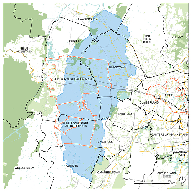
Case Study: Wianamatta South Creek Delivery Strategy
Wianamatta South Creek is a major tributary of the Hawkesbury-Nepean River in the western Sydney Basin that runs 80 km from Narellan to Windsor. A large part (80%) of the 63,000 ha catchment falls within the Western Parkland City urbanised area, covering 6,000 km2 and eight local government areas. The catchment is experiencing both rapid and incremental scales of change from rural to predominantly urban land use, including development of the Western Sydney Aerotropolis precinct.
Wianamatta South Creek and its catchment has a critical role to play in realising the vision for the Western Parkland City to create cool, green and attractive urban communities by retaining water in the landscape, integrating water cycle planning in the design of new neighbourhoods and supporting the health and management of waterways.
This vision has been captured in several strategic land use planning frameworks, including the Greater Sydney Region Plan and Western City District Plan, with links to the proposed Design and Place State Environmental Planning Policy.
Premier’s priorities for open space and greening are also key requirements, with about two million trees to be planted in the area.
New integrated land use and water cycle management approaches and major policy reforms are required to achieve the economic, amenity and environmental objectives of the Western Parkland City. Reflecting this, the South Creek Catchment Sector Review identified changes to land use controls and major water- related infrastructure investment decisions:
- Stage 1 of the South Creek Sector Review identified significant economic value in taking an integrated approach to land use, water cycle management and investment in advanced recycling water infrastructure in developing the Western Parkland City. This value was estimated at around $6.6 billion (NPV), compared to a business-as-usual approach
- Stage 2 of the South Creek Sector Review included a strategic economic analysis of stormwater and waterways governance, which found that a catchment-wide approach to planning and delivery of stormwater infrastructure and waterways management could deliver a significant economic benefit (which is being investigated further).
To achieve these changes, a Delivery Strategy is being developed to provide an adaptive and tactical 40-year framework and the tools needed for integrated land use and water cycle management for the Wianamatta South Creek catchment. The strategy focuses initially on actions aligned with planning for the Western Sydney Aerotropolis.
The Delivery Strategy will cover green and blue infrastructure, land use outcomes, catchment health and flooding, connected spaces and the interfaces and relationships with future development, utilities and transport. It will also address current and future land controls and ownership, and is being developed collaboratively with Aboriginal communities, landholders, local government, Sydney Water and other stakeholders. A key first step is Sydney Water’s planning for the Upper South Creek Advanced water recycling scheme.