A NSW Government website

About the Strategy

Our water resources and how we share them

Water in NSW is managed and shared according to a framework of rules, rights and entitlements, with limits in place to protect this valuable resource.

Water management is complex. It involves water, planning and environmental laws and policies, statutory rules and plans about sharing water, trading in water entitlements and water allocations, the operation of public and private infrastructure, and a range of decision-making, monitoring and enforcement agencies. It also extends across state boundaries.

Water management in NSW covers approximately 58,000 km of rivers and major streams:

  • West of the Great Dividing Range, long, slow moving rivers flow westward across flat landscapes, with some running through to the ocean at the mouth of the Murray River near Adelaide (generally long, low gradient inland rivers).
  • East of the Great Dividing Range, the terrain is steeper and the climate is generally wetter with faster flowing rivers that run east to the ocean (short, high gradient coastal streams).

Some of these river systems are regulated (controlled by major publicly owned dams or weirs). In these systems, water licence holders can order water from the dam and then take water from the river according to their licences.

In unregulated rivers and streams, water users are reliant on natural water flows and rainfall. In some systems, flood waters are harvested from the floodplain.

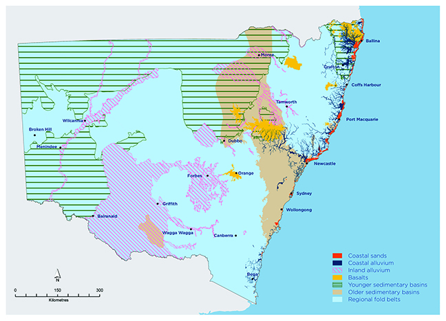
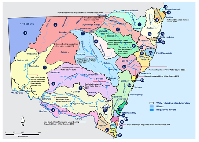
Groundwater is also a valuable resource for NSW, supplying 20-30% of all water needs. Figure 10 shows a simplified picture of groundwater resources in NSW and Figure 11 shows major regulated rivers and unregulated river water sources.

Map showing overview of NSW groundwater resources
Figure 10. Overview of NSW groundwater resources
Map of NSW showing surface water sources
Figure 11. NSW surface water sources
Legend:
  1. North Western Unregulated and Fractured Rock Water Sources 2011
  2. Intersecting Streams Unregulated River Water Sources 2011
  3. Lower Murray-Darling Unregulated River Water Source 2011
  4. Murray Unregulated River Water Sources 2011
  5. Murrumbidgee Unregulated River Water Sources 2012
  6. Lachlan Unregulated River Water Sources 2012
  7. Macquarie Bogan Unregulated Water Sources 2012
  8. Castlereagh Unregulated Water Sources 2011
  9. Namoi and Peel Unregulated Water Sources 2012
  10. Gwydir Unregulated Water Sources 2012
  11. NSW Border Rivers Unregulated River Water Sources 2012
  12. Tweed River Area Unregulated and Alluvial Water Sources 2010
  13. Brunswick Unregulated and Alluvial Water Sources 2016
  14. Richmond River Area Unregulated, Regulated and Alluvial Water Sources 2010
  15. Clarence River Unregulated and Alluvial Water Sources 2016
  16. Coast Harbour Area Unregulated and Alluvial Water Sources 2009
  1. Bellinger River Area Unregulated and Alluvial Water Sources 2020
  2. Nambucca Unregulated and Alluvial Water Sources 2016
  3. Macleay Unregulated and Alluvial Water Sources 2016
  4. Hastings Unregulated and Alluvial Water Sources 2019
  5. Lower North Coast Unregulated Water and Alluvial Water Sources 2009
  6. Hunter Unregulated Water and Alluvial Water Sources 2009
  7. Central Coast Unregulated Water and Alluvial Water Sources 2009
  8. Greater Metropolitan Unregulated River and Alluvial Water Sources 2011
  9. Clyde River Unregulated and Alluvial Water Sources 2016
  10. Deua River Unregulated and Alluvial Water Sources 2016
  11. Tuross River Unregulated and Alluvial Water Sources 2016
  12. Murrah-Wallaga Area Unregulated and Alluvial Water Sources 2016
  13. Bega and Brogo Rivers Area Regulated, Unregulated and Alluvial Water Sources 2011
  14. Towamba River Unregulated and Alluvial Water Sources 2010
  15. Snowy Genoa Unregulated and Alluvial Water Sources 2016
  16. Australian Capital Territory no water sharing plan